

On a river in southwestern Nova Scotia, a historical detective’s inquiry is bringing to light forgotten remnants of North America’s history.
Allains River, formerly known as Lequille River, meanders as a tributary of the Annapolis River, stretching from the heart of the province to present-day Annapolis Royal.
Four centuries ago, the river hosted one of the earliest industrial sites established post-colonization: a flour mill erected in 1607 and later destroyed by fire in 1643.
For generations, the mill’s precise location remained a puzzle. However, an amateur historian from the United States, along with a team of researchers and archaeologists, are now making progress in pinpointing its whereabouts, unveiling insights into the history of colonization, interactions, and the enduring presence of the Mi’kmaw people in Nova Scotia.
“This is an intriguing mystery to unravel, and it holds immense historical significance,” remarked Mark Borton, a Connecticut-based writer who kickstarted the quest to locate the Poutrincourt gristmill.
Dating back to 1605, a fortified fur-trading post was constructed at what Samuel de Champlain dubbed Port Royal on the Annapolis Basin. The settlers necessitated a mill to produce flour as bread accounted for a substantial portion of the French diet at the time.
The Poutrincourt gristmill, a water-driven grain grinding mill, is depicted on historical maps, including Champlain’s cartography.
Captivated by Champlain’s map, Borton, formerly a producer of East Coast boating guides, embarked on a journey to the Maritimes in 2018, igniting his interest in tidal power and the Bay of Fundy. Upon encountering Champlain’s map during his research, Borton immediately recognized the mill’s significance.
“We are in search of the oldest mill in North America, marking the inception of industrial power on the continent. This represents a pivotal moment,” Borton emphasized.
The challenge for Borton and his predecessors lay in the fact that contemporaneous maps did not accurately reflect the terrain. Over time, various theories emerged regarding the mill’s possible location.
Contrary to prevailing theories, Borton believes the mill might lie in a location “beyond” these historical assumptions. By integrating elements from Champlain’s map with present-day geographic features, Borton narrowed down a potential site. Through remote investigation via Google Maps from his residence in Connecticut, Borton identified a faint square on the marsh’s periphery that could signify a foundation.
“Man-made structures like squares do not naturally occur in tidal marshes. That finding aligned with my search criteria,” he observed.
After securing a permit from the Nova Scotia Museum, Borton proceeded with his exploration.
One clue pointing to the mill’s location was Champlain’s mention of a Mi’kmaw fishing weir across from the mill on his map. Zooming in on Google Maps, Borton noticed a cluster of rocks at that precise riverbank spot, indicative of human intervention.
While the area between the weir and the presumed mill site now appears as a marsh, Champlain’s map portrays it as an island. Borton speculated that the French might have constructed dikes in that region, although historical maps did not record any such dikes.
Seeking assistance from the Nova Scotia Community College, Borton requested a lidar map, a remote sensing technology for creating precise 3D maps. The resulting maps revealed straight lines and indications of dikes dating back to the early 17th century.
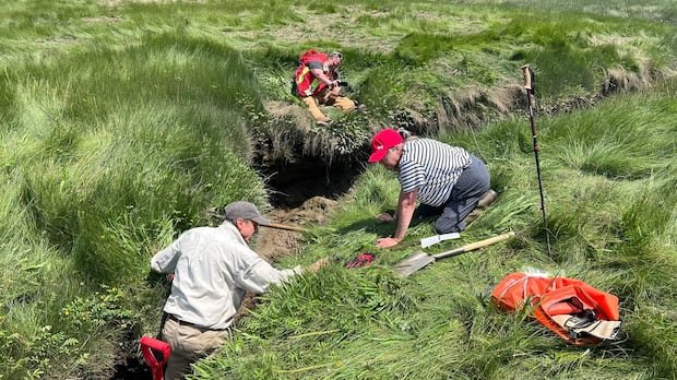
During the summer, Borton and the Nova Scotia Museum’s team collected samples from the wooden and brush piles forming the interior of these dikes for radiocarbon dating, enhancing the credibility of their theories.
In addition to Borton’s efforts, archaeologists from Kwilmu’kw Maw‑klusuaqn and Saint Mary’s University are joining forces to investigate this historical period marked by French-Mi’kmaq interactions.
Jonathan Fowler, an anthropology professor at Saint Mary’s, underscored the significance of Allains River in this historical narrative, representing a convergence of European and Mi’kmaw land utilization practices.
Fowler’s team intends to utilize ground-penetrating radar to delve further into the mill’s potential site, aiming to uncover more insights into this era of mutual cooperation and land sharing between different cultures.
The project has not only shed light on historical sites along Allains River but has also fostered collaboration and unity among participants, earning praise for Borton’s role as a catalyst in this communal effort.
Borton’s investigations have revealed several additional mill sites in the vicinity, suggesting a rich historical tapestry waiting to be preserved for future generations to appreciate and learn from.